Sunday, 4 November 2018

600-575BC in the Near East

Dragon brickwork from the Ishtar Gate of Babylon
This blog post will be looking at the years 600-575BC in the Near East, which for the purposes of this blog will include Kush and Lydia in the south and west, far over to the easternmost reaches of the Median Empire and to the Caucasus in the north. Occasionally there may be references to other regions, but the Greek world in particular will be dealt with in a separate post.

The sources for this blog will include as much primary sources as possible, particularly Neo-Babylonian chronicles and other cuneiform writings. Lydian and Median sources are so scant as to be almost non-existent, and those that do exist may in fact be forgeries. Egyptian and Kushite inscriptions will be used where possible, but there are not as many of these as we would like. The Hebrew Tanakh or Old Testament will be used where possible, but this has a very narrow focus and is not contemporary with the events that it describes. Also, the writers of the books of Kings, Chronicles, Jeremiah, etc. are not writing history as such and their writings have their own specific conventions. The source material that we shall see becoming ever more prevalent during this period, is the later writings of the Greeks. For better or for worse, shortly after the fall of Assyria, we begin to have fewer and fewer writings directly from the Mesopotamians.

Inscription of Nebuchadnezzar
detailing the rebuilding of the Ebabbar
temple in Sippar
As always I feel it is important to note that I am not a professional historian. The facts and dates in this post should be treated with due caution and everything should be checked. There are certainly mistakes and errors in the sources and I may make mistakes in my interpretations of these sources. Mistakes are particularly likely to occur when dealing with years, as the Babylonian and Jewish years do not correspond exactly to our own. So, there is the possibility that I may have, for example, interpreted an event as happening in late 609 when it may in fact have been early 608. If the reader spots any errors such as this, please let me know in the comments and I will research it and correct it as soon as possible. Also, another thing that will affect dating for this period is whether the king counts the first year of their reign as the 1st year or the 0th year (counting from accession or from first full year). Even professional historians have differing opinions on the exact ordering of events at this time, so exact precision is not likely here.

It can be useful to give context to the period by describing what is happening elsewhere in the world at this time. In China, the Zhou Dynasty was continuing its long slow decline, while the feudal states such as Jin and Chu grew ever more important and waged wars between them for influence. In India, there were a number of powerful kingdoms, particular in the north along the Gangetic Plain. These kingdoms were known as the Mahajanapadas and included states such as Kuru, Panchala, Kosala, Videha and Magadha. In India at this time a number of sects began to spring up that in certain cases had unusual interpretations of the accepted beliefs of the time and region, but this is a topic for another blog. To the west, in Greece, poets and tyrants flourished along with the beginnings of Greek science and philosophy. These will all be spoken of in later blogs, but this should give a rough idea of the state of the world at this point.

Gold coin of the Mermnad Dynasty of Lydia
When we begin our time period, we can see that the fall of the Assyrian Empire had left three powers, Media, Babylon and Lydia in its place and that these three, in combination with Egypt, now dominated the region. Each of these large kingdoms had strong rulers: Alyattes II in Lydia, Nebuchadnezzar II in Babylon, Cyaxares in Media and Necho II in Egypt. Smaller kingdoms were dotted around the region, but were relatively insignificant in comparison to these three.

In the year 600 the Babylonians were rebuilding their army after suffering a defeat while attempting an invasion of Egypt the previous year. Their western client kingdom of Judah was in revolt and Babylonian rule west of the Euphrates was jeopardised. Necho II of Egypt seems to have tried to support the rebellion of the kingdom of Judah by attacking and capturing the city of Gaza, which was also an important trading post.

In Judah the prophet Habbakuk was probably active around this time and the book that bears his name may have been written around this time, however dates are not explicitly given in this work and it may be later. In Kush, to the south of Egypt, the king Anlamani died and was succeeded by his brother Aspelta.

Outlined tablet showing silhouette of
the Etemenanki
As for the Etemenanki — the ziggurat of Babylon, which had become very weak and had been allowed to collapse before my time — the god Marduk — my lord — commanded me to firmly secure its foundation on the surface of the netherworld and to have its summit rival the heavens. 
Nabopolassar 5, i 19

Around this time, the Etemenanki, the huge ziggurat in Babylon, was rebuilt. The reconstruction of this had begun under the Assyrian kings, but the revolt of Shamash-shuma-ukin had probably put a stop to it. Nabopolassar had begun to rebuild, it but the work was only completed under his son, Nebuchadnezzar II. The tower reached 91 metres and was one of the tallest structures on earth at the time. Some have speculated that this gigantic tower was the inspiration for the story of the Tower of Babel, but ziggurat towers were well known in the Near East. It is possible as well that its ruins were the inspiration for the Hanging Gardens of Babylon, but again, this is highly speculative.

In the sixth year [599/598] in the month of Kislimu the king of Akkad (Nebuchadnezzar) mustered his army and marched to the Hatti-land (west of the Euphrates River).  From the Hatti-land he sent out his companies, and scouring the desert they took much plunder from the Arabs, their possessions, animals and gods. In the month of Addaru the king returned to his own land.
Babylonian Chronicles ABC5 (Jerusalem Chronicle)

Around the year 599 the Babylonian army had been reorganised after the defeat near Egypt and was campaigning once more. The army marched west and probably quelled rebellions among the nomad tribes near the Jordan River. The tribes in question were probably the Kedarite Arabs, who had desert cities in Dumatha and Tayma. This campaign probably served to strengthen the kings of Moab and Edom who had acted as allies of Babylon against the rebellious kingdom of Judah.

Babylonian World Map from Sippar
Around this time the Ebabbar Temple, dedicated to the Sun God Shamash, in the sacred city of Sippar, was restored by Nebuchadnezzar. He left inscriptions describing his rebuilding of the temple and the city seems to have prospered under his rule. This is as good a place as any to mention the Babylonian map of the world that was discovered in Sippar and may come from this time period. Dates cannot be exact of course, but the map does date from this century. It appears to show a conceptual picture of a circular world, surrounded by mountains. The furthest places that it shows are Urartu and Susa, meaning that it shows a very limited picture of the world. But despite the fact that we are not sure of its exact use (the tablet itself is broken), we can be sure that this is the oldest map currently possessed by humanity. There are Greek maps that were supposedly made in this century as well, but they are not preserved in their original form.

Also made around this time are the Ketef Hinnom scrolls. These were little silver scrolls that were made in Jerusalem that were probably used as amulets. They are interesting in that they are the earliest known quotations from the Hebrew Bible and contain versions of the Priestly Blessing from the Book of Numbers. Similarly to the Babylonian map, the exact dating of these is unclear, but it is believed to be around this time, so I thought that I would mention them here.

One of the Ketef Hinnom scrolls
YHWH, keep you. Make shine, YHWH, His face upon you and grant you peace.
Ketef Hinnom KH2 Apotropaic Amulet text

In 598 the Babylonian army continued the campaign in the Levant and probably began to besiege Jerusalem, which was in revolt under the leadership of Jehoiakim. Jehoiakim died however and was buried in the tombs of the kings while the siege was ongoing. Jehoiachin succeeded his father, but only reigned for a few months.

And Jehoiachin the king of Judah went out to the king of Babylon, he, and his mother, and his servants, and his princes, and his officers: and the king of Babylon took him in the eighth year of his reign. And he carried away all Jerusalem, and all the princes, and all the mighty men of valour, even ten thousand captives, and all the craftsmen and smiths: none remained, save the poorest sort of the people of the land. And he carried away Jehoiachin to Babylon, and the king's mother, and the king's wives, and his officers, and the mighty of the land, those carried he into captivity from Jerusalem to Babylon. 
2 Kings 24:12,14-15 

In 597 the city was surrendered to the Babylonians, but this did not save the king. Jehoiachin was dethroned and sent away to Babylon, along with many high-ranking prisoners who were also deported. The city was plundered and the loot sent eastwards to Babylon with the train of captives. The corpse of the rebel king Jehoiakim was taken from its tomb and thrown outside the city to be eaten by the wild beasts. After all this Mattaniah, a son of Josiah, was placed on the throne and his name changed to Zedekiah. It was expected that Zedekiah would prove loyal, as Babylonian patience with Judah must have been wearing thin. One of those deported to Babylon was a young man from a priestly family known as Ezekiel.

Inscription of Nebuchadnezzar II
In the seventh year, the month of Kislîmu (February or March 597), the king of Akkad (Nebuchadnezzar) mustered his troops, marched to the Hatti-land, and besieged the city of Judah and on the second day of the month of Addaru he seized the city and captured the king. He appointed there a king of his own choice, received its heavy tribute and sent to Babylon. 
Jerusalem Chronicle ABC 5 

In the year 596 Babylonian sources record that Elam, which had somehow managed to recover from the wars of the previous century, made some form of attack against Babylonia. The armies of Babylon returned from the west and fought a campaign against the Elamites that seems to have ended in an Elamite withdrawal. It is not clear if Nebuchadnezzar pursued the Elamites or invaded Elam himself, but some form of punitive action probably took place.

Partiall reconstructed ruins of Babylon
While there was still a distance of one day's march between them, the king of Elam was afraid and, panic falling on him, he returned to his own land.
Jerusalem Chronicle ABC5 

In 595 it seems that Sarduri IV of Urartu died and was succeeded by his brother Rusa IV. Urartu at this point seems to have been ruined; a shadow of its former self and this once mighty kingdom would fade out with barely a whimper in historical sources.

In this year there seems to have been a rebellion against Nebuchadnezzar in Babylon. This civil war was dealt with quite quickly and the rebellion was crushed. We know very little about who exactly was rebelling or what their motivations were.

Inscription of Nebuchadnezzar II
In the tenth year the king of Akkad (Nebuchadnezzar) was in his own land; from the month of Kislîmu to the month of Tebetu there was rebellion in Akkad. With arms he slew many of his own army. His own hand captured his enemy.
Jerusalem Chronicle ABC5 

Also in this year Necho II died and was succeeded by his son Psamtik II in Egypt. This is as good a time as any to remember the achievements of Necho II. He was the son of Psamtik, who was remembered by Herodotus as trying to discover the first language of man, in what may have been the first experiment recorded in history. Necho continued this tradition of boldness, both in his daring campaign that expanded Egyptian power briefly to the Euphrates and in the exploration and building projects he completed.

Necho II is supposed to have attempted to link the Red Sea to the Nile in the earliest version of the Suez Canal to have been attempted. This was a gigantic work and was truly a work of vision, but there were problems with it, namely that there is a considerable difference in water levels between the two bodies of water. There are no Egyptian inscriptions for this, but we know the story from Herodotus, who says that Necho II stopped construction after receiving an unfavourable oracle.

Necho II then appears to have commissioned an even more intriguing expedition. He hired Phoenician sailors, the greatest sailors of the ancient world, to set sail from the Red Sea and to attempt to circumnavigate Africa. According to Herodotus, who again, is our sole source for the story, the sailors did not return for a long time but did eventually arrive back in Egypt having sailed around the continent and coming back through the Straits of Gibraltar. This was an unprecedented feat and one that was not to be repeated to our knowledge until the Age of Exploration. The sailors told tales of the sun being in the wrong position, which led the Greeks, and perhaps the Egyptians, to discount the story. This however makes it much more plausible, as it suggests that the Phoenicians did in fact reach the southern hemisphere.

Earlier Assyrian relief of Phoenician sailors
on riverboats
For Libya shows clearly that it is bounded by the sea, except where it borders on Asia. Necos king of Egypt first discovered this and made it known. When he had finished digging the canal which leads from the Nile to the Arabian Gulf, he sent Phoenicians in ships, instructing them to sail on their return voyage past the Pillars of Heracles until they came into the northern sea and so to Egypt. So the Phoenicians set out from the Red Sea and sailed the southern sea; whenever autumn came they would put in and plant the land in whatever part of Libya they had reached, and there await the harvest; then, having gathered the crop, they sailed on, so that after two years had passed, it was in the third that they rounded the pillars of Heracles and came to Egypt. There they said (what some may believe, though I do not) that in sailing around Libya they had the sun on their right hand.
Herodotus, Histories: 4:42

Sadly for Necho II while he was a king of vision and energy, his projects nearly all failed. His armies lost to the Babylonians, the canal was not completed and the route around Africa was too long to be of practical use. He was a genius before his time perhaps.

Ankhnesneferibre
When Psamtik II took the throne he instated his daughter Ankhnesneferibre as Divine Adoratrice of Amun in Thebes. This was in the year 595 or 594 depending on what is counted as the first year. This was an important position, in certain ways perhaps the second most important position in Egypt after the Pharaoh himself, so it was important to ensure that this post was held by someone loyal to the dynasty. Nitocris I adopted the princess to ensure that she would become God’s Wife on the death of Nitocris. Thus the Saite Dynasty further strengthened its hold on the southern part of Egypt.

Year 1, third month of the third season, day 29, under the majesty of Horus: Favourite of the Two Goddesses: Mighty of Arm; Golden Horus: Beautifying the Two Lands; King of Upper and Lower Egypt: Psamtik II, given life. On this day the king's-daughter, Ankhnesneferibre, arrived at Thebes. Her mother, the Divine Consort, Nitocris, who liveth, came forth to behold her beauty, and they went together to the House of Amon. 
Stela of Ankhnesneferibre 

In 594, after the rebellion was crushed in Babylon, the Babylonian army seems to have moved back to the western part of the empire to continue campaigning. There were continued tensions with the Egyptians who had raised a fleet of Phoenicians and Greeks and were attacking the Mediterranean coasts. The loyalty of Tyre and Sidon and other Phoenician cities to Babylon was very suspect as well. There are references to the Babylonians besieging Tyre around this time, but I have found that the dates are highly inconsistent, possibly because there was more than one siege.

Possibly as part of this western campaign Zedekiah king of Judah was summoned to Babylon and made the trip with several high ranking officers of his court. Presumably this was to show that he was still loyal to Nebuchadnezzar and that he was able to give the tribute that was required of him.

Inscription of Nebuchadnezzar II 
This is the message Jeremiah the prophet gave to the staff officer Seraiah son of Neriah, the son of Mahseiah, when he went to Babylon with Zedekiah king of Judah in the fourth year of his reign. 
Jeremiah 51:59 

In 593 the Babylonians continued their campaigns in the Levant, but it is not clear against whom exactly. In this year the so-called Jerusalem Chronicle (because it refers to the capture of Jerusalem in 598/597) comes to an end and our main sources of Babylonian history grow silent. We have been spoiled by the Assyrian and Babylonian records from the reigns of Tiglath-Pileser III onwards, but from here the contemporary records become more fragmentary unfortunately.

Perhaps around this time, the passage simply says early in Zedekiah’s reign, there was a confrontation between Jeremiah and Hananiah, the prophets who were prominent in the pro-Babylonian and pro-Egyptian groups in Jerusalem. At this point there were a number of envoys from the surrounding kingdoms in Jerusalem; from Edom, Moab, Ammon, Tyre and Sidon. Why they were here is not exactly clear, but the most likely answer is that the kings of the region were plotting an uprising. Jeremiah made a yoke that he wore and proclaimed that everyone who wore the yoke of Babylon would live. Hananiah seized the yoke and broke it, saying that within two years the exiles would return. This was a blatant challenge to Jeremiah, as Jeremiah had previously proclaimed that the exile would last seventy years. Jeremiah then proclaimed that, in exchange for the yoke of wood that had been broken, the Babylonians would rule with a yoke of iron and prophesied Hananiah’s death.

Psamtik II
In 592 Psamtik II became worried about the power of Kush and launched an attack against the Kushite king Aspelta. His army moved downstream with boatloads of soldiers and mercenaries, including large contingents of Greeks and Carians as bronze-clad soldiers of fortune looking to make money in distant lands. The Greeks gazed in awe at the statues of Ramesses II at Abu Simbel and proceeded to do what tourists always do, and carve their names all over the ancient site. Some of their graffiti still survives, as they record who they are and who led them for all time.

When King Psammetichus came to Elephantine, this was written by those who sailed with Psammetichus the son of Theocles, and they came beyond Kerkis as far as the river permits. Those who spoke foreign tongues (the Greeks and Carians) were led by Potasimto, the Egyptians by Amasis. 
Graffito at Abu Simbel written in Greek 

The campaign against the Kushites was at least a partial success and Napata may have been ransacked forcing the Kushite capital to move south to Meroe. Psamtik II set up a victory stela but it is extremely formulaic and not overly detailed as to what exactly happened. It is clear that even after the capital was moved that the Kushites still controlled Napata and were generally buried nearby in the cemetery of Nuri.

Kushite royal tombs at Nuri, near Napata
The Nubians of every hill-country rose up against him, their hearts full of rage against him. His attack took place, and it was misery for the rebels. His majesty has done a fighter’s work. When the battle was joined the rebels turned their backs. The arrows did not stray from piercing them. The hand did not let loose. One waded in their blood as in water. Not one bound pair escaped of the 4,200 captives. A successful deed has been done!”
Psamtik II Victory Stela 

After the successful attack on Kush Psamtik II seems to have campaigned in the Levant as well to try and stir up revolt against the Babylonians, either in late 592 or in 591. Judah seems to have been in turmoil, with a pro-Egyptian party and a pro-Babylonian party. Jeremiah the prophet seems to have either led, or been important in, the pro-Babylonian party. The pro-Egyptian party was possibly led by a prophet called Hananiah, who may have died at this point.

The situation was complicated by the fact that there were probably supporters of the deposed king Jehoiachin who were keen to topple Zedekiah. The situation was complicated further still by the fact that many of the exiles in Babylon seem to have stayed in contact with the people in Jerusalem and the exiles had their own factions as well. It was into this maelstrom of politics and prophecy that Psamtik II entered with the Egyptian army. In either 592 or 591, Zedekiah of Judah succumbed to the pressure of the pro-Egyptian faction and Judah rose in rebellion against Babylon.

Ruins of the Temple of Amun in Meroe
Exiled faraway in Babylon, Ezekiel, who had been exiled along with those taken with Jehoiachin, began to prophesy. Ezekiel was of the group that could roughly be called pro-Babylonian. This is not to imply that they liked the Babylonians. Jeremiah and Ezekiel certainly did not like their conquerors, but they did counsel patience for those who had been taken into exile and submission for those who remained.

On the fifth of the month—it was the fifth year of the exile of King Jehoiachin— the word of the Lord came to Ezekiel the priest, the son of Buzi, by the Kebar River in the land of the Babylonians. There the hand of the Lord was on him. I looked, and I saw a windstorm coming out of the north—an immense cloud with flashing lightning and surrounded by brilliant light. The centre of the fire looked like glowing metal, and in the fire was what looked like four living creatures. In appearance their form was human, but each of them had four faces and four wings. 
Ezekiel 1:2-6 

Lydian brooch decoration
Finally, around this time there is a strange tradition in later Judaism that suggests that Jeremiah hid the fire from the temple somewhere on Temple Mount and then separately hid the Ark of the Covenant somewhere on Mount Sinai. These are later traditions and almost certainly ahistorical but I found them interesting so I thought that I would make a mention of them. They are certainly intriguingly mysterious even if almost certainly untrue.

These same records also tell us that Jeremiah, acting under divine guidance, commanded the Tent of the Lord's Presence and the Covenant Box to follow him to the mountain where Moses had looked down on the land which God had promised our people. When Jeremiah got to the mountain, he found a huge cave and there he hid the Tent of the Lord's Presence, the Covenant Box, and the altar of incense. Then he sealed up the entrance.
2 Maccabees 2:4-5

In 591 some sources that I have come across suggest that Sadyattes of Lydia dies at this time and that Alyattes II succeeds. This might be true, but honestly the chronology of the Mermnad Dynasty of the Lydian kingdom is not well known. Not knowing which, if either, date is correct I have mentioned both: 619 and 591. The important thing is of course that Alyattes II follows Sadyattes on the throne of Lydia.

Ruins of city of Teishebaini
In 590 the city of Teishebaini in Urartu is sacked, probably by the Medes. War broke out between the Medes and the Lydians, presumably over the remnants of the Urartian kingdom, which at this point was probably no more than a few cities, if even that. At stake in the war between the mighty powers of Media and Lydia was where the border between them should lie. However, Herodotus records that the war was fought because Alyattes refused to give up refugees that had fled from Media. This is quite possible as well, as extraditions were quite important for ancient states.

Also around this time a prophet in Jerusalem named Obadiah spoke a short prophecy against Edom, a nearby kingdom to the south that was related to the kingdom of Judah and had previously been allied or tributary to the larger kingdom. When Nebuchadnezzar had attacked Jerusalem the Edomites had assisted in the loot and Obadiah prophesied the destruction of their kingdom as a result. It is not clear if this was the exact time of the vision and the writing, but the context certainly fits.

Psamtik II temple at Hibis
On the day you stood aloof while strangers carried off his wealth and foreigners entered his gates and cast lots for Jerusalem, you were like one of them. You should not gloat over your brother in the day of his misfortune, nor rejoice over the people of Judah in the day of their destruction
Obadiah 11-12

In the year 589 Psamtik II of Egypt died. He had been an energetic Pharaoh who had campaigned to the south and east. He had done major building works in Egypt, including the monumental temple at Hibis that still stands to this day. He was succeeded by Wahibre, better known by his Greek name Apries, but referred to by the Hebrews as Hophra.

The remains of an Assyrian siege ramp at Lachish
This may have been reused by the Babylonians
The Babylonian armies returned to the west of their empire to crush the revolt of Zedekiah. The army of Judah was nowhere near strong enough to meet the Babylonians in open battle, so they resorted to other tactics. Much of their army was set to defend the three main cities remaining in Judah: Jerusalem, Lachish and Azekah. Other contingents would be sent out to the hills to act as raiders and to send fire signals between the besieged cities. Other contingents would be sent out to the neighbouring kingdoms to assist in other revolts and a large contingent was probably sent to Egypt to join the forces of the Egyptians who would come to their aid. It is possible that the siege of Jerusalem was begun by the Babylonian forces in 589, although Nebuchadnezzar himself seems to have stayed near Riblah where he could conduct other operations against other cities simultaneously.

The commander of the army (of Judah) Konyahu son of Elnatan, has gone down to go to Egypt and he sent to commandeer Hodawyahu son of Ahiyahu and his men from here.
Lachish Letter 3

As a side note, it is possible that the book of Judith is meant to be set in this period, as it refers to a king called Nebuchadnezzar who invades Judah, but the references are hopelessly confused and do not really fit any actual historical period.

Painting of Judith and Holofernes
by Vincenzo Catena
Now in the twelfth year of his reign, Nabuchodonosor king of the Assyrians, who reigned in Ninive the great city, fought against Arphaxad and overcame him 
Judith 1:5 

In 588 the Babylonians continued the attack on the three cities, presumably after having first attacked and destroyed the remaining less well-fortified cities in the land of Judah. Through an accident of history we have a primary source for the siege of Lachish. A broken pot was used to write down messages that were received by the garrison of Lachish. The messages were probably sent by fire-signals from the hills, allowing the commanders to talk to each other despite being under siege, and then transcribed for reading before being discarded near the gates, where they were found in the 20th century by archaeologists. The messages talk about confidential documents, army contingents being sent to Egypt, prophets and discouraging news in Jerusalem, and a host of other interesting information.

The sieges do not seem to have lasted long, as almost immediately the Babylonians received word that Apries, king of Egypt, had sent his armies from Egypt to fight them. Possibly Apries had landed troops further north in Phoenicia rather than sending his army out across the northern coast of the Sinai. Whatever route was taken, the Babylonians withdrew their armies from Judah to meet this new threat.

When the Babylonian armies withdrew to face the Egyptians, Jeremiah, a prophet who had been vocal in counselling submission to Babylon, attempted to leave the city and was arrested as a likely defector to the enemy. The prophet was imprisoned, but not executed, as King Zedekiah still respected him.

Pharaoh’s army had marched out of Egypt, and when the Babylonians who were besieging Jerusalem heard the report about them, they withdrew from Jerusalem. … But when he reached the Benjamin Gate, the captain of the guard, whose name was Irijah son of Shelemiah, the son of Hananiah, arrested him and said, “You are deserting to the Babylonians!”
Jeremiah 37:5,13

Seal of Gedaliah son of Passhur
The Babylonian army soon returned, having dealt with the Egyptian army, and now Jeremiah’s continued prophecies about the city falling could not be stood any longer by the pro-Egyptian party who demanded his death. Even his enemies could not stand to put a prophet to death however and he was placed in a dry well to starve to death until he was rescued by Ebed-Melek the Kushite Considering the recent war between Egypt and Kush, Ebed-Melek is unlikely to have been pro-Egyptian. One of those who had thrown Jeremiah into the well was Gedaliah, the son of Passhur, whose seal was discovered in Jerusalem in 2008.

Jeremiah spent the remainder of the siege under arrest, but not in threat of death, which shows the respect that prophets were given, even if their actual words were not followed. The pro-Egyptian and pro-Babylonian were not even the only factions and sub-groups in the besieged city, as there were followers of a conservative sect of Judaism, known as Recabites that had also fled for shelter there as well. It is a good reminder that just as there were profusions of sects in later stages of Judaism, that there were likely to have been a number of sects at this time as well.

Then Jeremiah the prophet told all this to Zedekiah king of Judah, in Jerusalem, while the army of the king of Babylon was fighting against Jerusalem and the other cities of Judah that were still holding out—Lachish and Azekah. These were the only fortified cities left in Judah.
Jeremiah 34:6-7

When the Babylonians returned to the attack they launched simultaneous sieges against Azekah, Lachish and Jerusalem. It seems that first Azekah fell and then Lachish. Even with the strengthening of the cities and the fire-signal communications from the hills, there was no resisting the Babylonian armies.

Replica of one of the Lachish Letters
And may (my lord) be apprised that we are watching for the fire signals of Lachish according to all the signs which my lord has given, because we cannot see Azekah. 
Lachish Letters No 4. 

While Lachish and Azekah may have fallen quickly, Jerusalem seems to have held out for eighteen months, during which time the Babylonians built siege ramps and battered at the walls while inside the walls the people starved. Partway through the siege the people of Jerusalem decided to curry favour with their God by freeing their slaves, but seeing that the siege continued regardless, they re-enslaved them again. They were castigated for this by Jeremiah from his imprisonment. It’s not exactly clear when this happened, but if the siege was resumed in 588, then it is likely that the freeing and re-enslaving took place in 587. This is one of the few noted attempts at emancipation in the ancient world, despite the fact that it did not last.

So all the officials and people who entered into this covenant agreed that they would free their male and female slaves and no longer hold them in bondage. They agreed, and set them free. But afterward they changed their minds and took back the slaves they had freed and enslaved them again. 
Jeremiah 34:10-11 

In 586 Jerusalem fell to the Babylonians. Possibly it was 587, as the sources have some ambiguity in them, but it was either one year or the other. The city wall was breached and the Babylonians entered the city, where the people by all accounts were starving. Zedekiah and his officials fled the city and made it as far as Jericho before being captured. Zedekiah was taken to face Nebuchadnezzar at his command centre in Riblah. Here the sons of Zedekiah and the nobles of Judah were executed, while Zedekiah was blinded and brought to Babylon. Most people who had survived the sieges of the cities were deported to Babylon, although country dwellers were allowed to stay. Jeremiah was allowed to stay, as the Babylonians had heard that he had counselled against the siege.

A new governor, Gedaliah, a minor member of the royal house, was appointed, but there were to be no more kings. The city walls, damaged from the siege, were now torn down. The palaces of the rebel kings of Judah were put to the torch and the great temple of YHWH in Jerusalem was burned. This act meant that Babylon would never be forgiven by the survivors of the siege and that the very name of Babylon would become synonymous with oppression and evil to this day. The temple, built by Solomon, was the most important temple in the religion of Judah and was the focal point of the reforms of Hezekiah and Josiah. The destruction of this temple and the loss of the kings of the House of David would force a shift in the very nature of Judaism.

Computer generated reconstruction of the
Temple in Jerusalem
On the seventh day of the fifth month, in the nineteenth year of Nebuchadnezzar king of Babylon, Nebuzaradan commander of the imperial guard, an official of the king of Babylon, came to Jerusalem. He set fire to the temple of the Lord, the royal palace and all the houses of Jerusalem. Every important building he burned down. The whole Babylonian army under the commander of the imperial guard broke down the walls around Jerusalem. Nebuzaradan the commander of the guard carried into exile the people who remained in the city, along with the rest of the populace and those who had deserted to the king of Babylon. But the commander left behind some of the poorest people of the land to work the vineyards and fields. 
2 Kings 24:8-12 

Victory Stela of Psamtik II
I must apologise if readers of this blog have no interest in the history of Judaism. It is certainly very possible to have an interest in Egyptian or Babylonian history without being particularly interested in the fate of one small kingdom at the periphery of both empires. But I have found that, even though the sources are seldom contemporary, the sheer amount of sources about the history of Judah make it an interesting case. The description of the fall of Jerusalem given in Jeremiah is probably the best non-Greek account of a siege anywhere in the ancient world and gives us far more detail than the Babylonian sources. It is certainly fair to question that detail critically, but it is also important to note that it is there. Please also note that there are other interpretations of this data than the one that I have given, as the sources are full of detail, but not exhaustive enough to prevent interpretation.

While it might seem that the fall of Jerusalem is enough detail for one year, for the sake of completeness, it is worth noting that this year saw the death of Nitocris I, God’s Wife of Amun in Thebes. Her adopted daughter, the Divine Adoratrice Ankhnesneferibre, daughter of Psamtik II, became God’s Wife in her stead. It is worth remembering these powerful ladies, whose incomes and power were the equal of many kings and cities in the world at this time, even if they were technically priestesses rather than rulers.

In Year 4, fourth month of the third season, 8 day 4, of this king; went forth the Divine Votress, Nitocris, triumphant, to heaven. She joined the sun, the divine limbs mingling with him who made her. 
The Stela of Ankhenesneferibe 

Halys River, where the border was fixed between
the Medes and Lydians
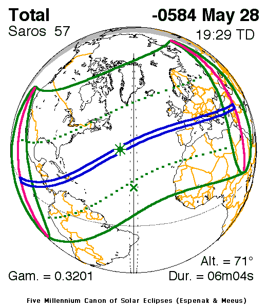
In the year 585, on the 28th of May, the war between Lydia and Media came to a head. According to Herodotus they had been fighting for five years and had even fought a night battle. Night battles were very rare in the ancient world. It was possible for them to be done, but the difficulties of commanding an army in the darkness and certain religious scruples generally meant that armies only clashed during the day. The general reluctance to fight in darkness may have influenced the end of the war.

On that day, the 28th of May 585BC, the armies of the Lydians and Medes were fighting at the Halys River when the sky darkened and a total eclipse of the sun occurred. The two sides took this as an omen and made peace, fixing the border between them at the Halys River. The date is one of the very few absolutely fixed dates in this period of history, because of course this event can be correlated with the eclipse times. Supposedly the event was predicted by Thales of Miletus, making this date as good a date as any other for the birth of science in the West, but we’ll discuss this more in the Greek blog for this period.

NASA image showing the path of the eclipse
Source
After this, since Alyattes would not give up the Scythians to Cyaxares at his demand, there was war between the Lydians and the Medes for five years; each won many victories over the other, and once they fought a battle by night. They were still warring with equal success, when it happened, at an encounter which occurred in the sixth year, that during the battle the day was suddenly turned to night. Thales of Miletus had foretold this loss of daylight to the Ionians, fixing it within the year in which the change did indeed happen. So when the Lydians and Medes saw the day turned to night, they stopped fighting, and both were the more eager to make peace. 
Herodotus Histories 1:74:1-3 

Around this time Cyaxares, the king of the Medes who had destroyed Nineveh and transformed his tribe into one of the most powerful kingdoms of the world, probably died. The dates are a little unclear but whatever the exact date, after the battle of the Halys River and the peace with Lydia, Cyaxares dies and his son Astyages succeeded him.

The Medes occupied Erebuni, present-day Yerevan, and the peace with Lydia allowed them to take over fully the lands of Urartu. The last king of Urartu, Rusa IV, disappears completely from history. He is poorly attested anyway, with only a few seals and almost no inscriptions. He may not have died fighting a last stand, but may have been a vassal king of the Medes. Perhaps Rusa’s death was similar to Zedekiah’s, as the empires consolidated their peripheral holdings.

Seal of Rusa IV, last king of Urartu
Finally, despite the fact that Jerusalem was destroyed, the Egyptian fleet was still a threat along the coast and the Phoenician city-states were restless against the Babylonians. It seems that Nebuchadnezzar began a siege against Tyre at some point around this time but the exact times are not clear. The city of Tyre was almost impossible to besiege by land, as half of it was set on an island, which could be resupplied with ease by the Tyrian ships, making it almost impossible to starve and impossible to assault with battering rams, etc. It’s not clear how exactly the Babylonians attacked the city but for thirteen years, according to Josephus, they were encamped around it and at war with it.

In the years 584 no political events happened to my knowledge. However, the Vision of the Valley of Dry Bones was recorded by Ezekiel in Babylon around this time. This was a dramatic vision that spoke of the prophet seeing a valley full of bones that were eventually raised to life in a striking metaphor for the rebuilding of the nation.

Ezekiel's Vision of the Valley of Dry Bones
The hand of the LORD was on me, and he brought me out by the Spirit of the LORD and set me in the middle of a valley; it was full of bones. He led me back and forth among them, and I saw a great many bones on the floor of the valley, bones that were very dry. He asked me, “Son of man, can these bones live?” I said, “Sovereign LORD, you alone know.”
Ezekiel 37:1-3

In 583 there is nothing that I can be certain happened in this year. It was however around this time that the Book of Lamentations in the Hebrew Old Testament was written. This was a lament over the fall of Jerusalem. It is written in a highly stylised manner, but conveying great emotion. Tradition has ascribed it to Jeremiah and this is possible but uncertain. As there is no fixed date for it I thought I would mention it here.

Remember, Lord, what has happened to us; look, and see our disgrace. Our inheritance has been turned over to strangers, our homes to foreigners. We have become fatherless; our mothers are widows. We must buy the water we drink; our wood can be had only at a price. Those who pursue us are at our heels; we are weary and find no rest. We submitted to Egypt and Assyria to get enough bread. Our ancestors sinned and are no more, and we bear their punishment. 
Lamentations 5: 1-7

Meanwhile, in Judah, which was now a Babylonian province, the Jewish governor Gedaliah had been trying to have the people return and to cultivate the land. The Babylonians appeared to rule with a fairly light hand and allowed those who had been scattered by the sieges and wars to return and farm the land, although rebuilding the Temple or the walls of Jerusalem would have been stopped immediately.

Stela of Apries of Egypt
When all the Jews in Moab, Ammon, Edom and all the other countries heard that the king of Babylon had left a remnant in Judah and had appointed Gedaliah son of Ahikam, the son of Shaphan, as governor over them, they all came back to the land of Judah, to Gedaliah at Mizpah, from all the countries where they had been scattered. And they harvested an abundance of wine and summer fruit.
Jeremiah 40:11-12

Some of the contingents of soldiers that had been sent to other kingdoms seem to have wanted to continue the war, or possibly were jealous of the new governor. One of these, an army commander distantly related to the House of David, called Ishmael, had a meeting with Gedaliah and assassinated him before fleeing in fear of retribution. Ishmael seems to have been acting on behalf of the king of Ammon, with whom he was seeking refuge. Not only had Ishmael killed Gedaliah, but he had slaughtered the Babylonians who were with him and killed a great number of others as well. The remainder were taken captive and taken with Ishmael to the Ammonites.

In the seventh month Ishmael son of Nethaniah, the son of Elishama, who was of royal blood and had been one of the king’s officers, came with ten men to Gedaliah son of Ahikam at Mizpah. While they were eating together there, Ishmael son of Nethaniah and the ten men who were with him got up and struck down Gedaliah son of Ahikam, the son of Shaphan, with the sword, killing the one whom the king of Babylon had appointed as governor over the land. Ishmael also killed all the men of Judah who were with Gedaliah at Mizpah, as well as the Babylonian soldiers who were there. 
Jeremiah 41:1-3

This had to have been an act of rebellion by the Ammonite King Ba’alis. While Ishmael and his soldiers might have viewed themselves as freedom fighters striking against collaborators it is hard not to see it as senseless violence years after a war was finished. The murder of Gedaliah is still remembered in Judaism and there is a Fast in his honour.

It’s hard to know what Ba’alis’ motivations were. It is hard to imagine that he thought he could defeat Babylon, but perhaps he hoped that the murder would be secret and could be blamed on the Jews. Little is known of him or of the fate of Ammon. Josephus suggests that Moab and Ammon was subsequently conquered by the Babylonians but they were already subject to Babylon. Perhaps Ba’alis was simply removed and another client king put in his place. As a historical aside, we are fortunate enough to have the seal of Ba’alis that was used to sign royal documents.

Seal of Ba'alis
Belonging to Ba'alis, King of Bnei Ammon
Seal of Ba’alis

The killing threw the remainder of the people of Judah into a panic. They assumed that they would be blamed for the murder and that they would be caught up in a war between Babylon and Ammon. This was not entirely groundless, as empires do not take kindly to their officials being assassinated. To escape from any Babylonian vengeance and against the strong opposition of Jeremiah, many of the remaining people fled from Judah down into Egypt, bringing Jeremiah with them.

So Johanan son of Kareah and all the army officers and all the people disobeyed the LORD’s command to stay in the land of Judah. Instead, Johanan son of Kareah and all the army officers led away all the remnant of Judah who had come back to live in the land of Judah from all the nations where they had been scattered. They also led away all those whom Nebuzaradan commander of the imperial guard had left with Gedaliah son of Ahikam, the son of Shaphan—the men, the women, the children and the king’s daughters. And they took Jeremiah the prophet and Baruch son of Neriah along with them. So they entered Egypt in disobedience to the LORD and went as far as Tahpanhes.
Jeremiah 43:4-7

Colossal statue of Aspelta of Kush
The Babylonians might have not retaliated against the remnant in the land, but fleeing to Egypt seemed to confirm their guilt so there may have been further deportations from the land in 581. The land of Judah by now must have been nearly depopulated.

In the year 580 Aspelta of Kush died and was succeeded by Aramatle-qo. Aspelta had been a strong ruler and while Psamtik II had forced him to move the capital to Meroe, he was still buried at Nuri, near the old capital of Napata. Kush was still a power to be reckoned with, even if it was no longer able to influence events in Egypt. There is however some slight evidence that Kush was embroiled in a power struggle between two lines of the royal family, which had been split with the takeover of Taharqa over a century before. The succession in Kush appears to have gone through the matrilineal line and there are a number of stelas of Aspelta that have been vandalised to excise not his name, but the names of his female ancestors. Aspelta himself may in fact have usurped the throne. He records that the people had searched for a new king, that the gods had been asked to confirm a new king and that the gods and people had approved of the choice. This may have been common practice but may also have been a usurper trying to legitimise his reign. Whatever the case, Aramatle-qo was the new king of Kush.

Seal of Cyrus I of Anshan
Also around this time, Cyrus I, the ruler of Persia and king of Anshan, died. The Persians at this point were a tribal people who were tributary to the Medes and controlled a small amount of territory to the east of Elam. Cyrus I probably had a brother called Ariaramnes who was a lesser chieftain among the people but subordinate to the main regnal line. Cambyses I, son of the deceased Cyrus, became the new king of the Persians.

There is not much that can be said for the years 579-575 so I will mention a few things that were prominent around that time but cannot be exactly dated. Firstly, the house of Egibi. These were a family in Babylonia who became extremely wealthy from commercial activities. They bought land and slaves and financed certain aspects of the Neo-Babylonian military. They gave loans for people to buy and sell and facilitated trade. They gave their slaves considerable leeway to carry out their own businesses and were the dominant force in commercial activities at this time. They are sometimes referred to as bankers but this is an overstatement. While they did give loans at 20% interest they were not primarily a banking establishment, although they were the closest thing to it at that time. Some older scholarly literature refers to them as Jewish, but it is almost certain that the Egibi family were Babylonian rather than Jewish. They would dominate trade for over a century, from about 600-480 and now seemed as good a time as any to mention them.

Another thing that is worth talking about is the literature that was being created by the exiled Jews in Babylonia. Lament songs were created that kept alive Jewish culture and have inspired works up until the present day. While many of the Psalms predate this and many postdate it I thought that 137th Psalm was a good example of them and thought that I would mention it here.

By the Waters of Babylon
Painting by Arthur Hacker
By the rivers of Babylon we sat and wept when we remembered Zion. There on the poplars we hung our harps, for there our captors asked us for songs, our tormentors demanded songs of joy; they said, “Sing us one of the songs of Zion!” How can we sing the songs of the Lord while in a foreign land? If I forget you, Jerusalem, may my right hand forget its skill. 
Psalm 137:1-5 

Lastly, around this time Nebuchadnezzar was doubtless expanding his empire and strengthening the frontiers, but we have no documentation of this. The Egyptian, Hebrew, Greek and Babylonian sources are all silent for these years, insofar as I can tell. However, we do know that Nebuchadnezzar embarked on a huge building program to make Babylon the strongest and most beautiful city in the world. To this end he surrounded Babylon with a vast system of walls, possibly the largest that had yet been built on earth and great ceremonial gates. The walls were listed in the first list of the wonders of the world. The greatest of the gates was the Ishtar Gate, which was connected to the processional way that the kings and statues of the gods would follow on state occasions.

The gate itself was a huge affair of blue glazed bricks, adorned with lions, bulls and dragons. Nebuchadnezzar had an inscription carved to highlight his great creation and this is the quintessential artefact of the Neo-Babylonian Empire. The gate survived relatively intact throughout the millennia and sections of it can be seen in the Louvre and in Istanbul. The majority of it however was shipped over to Berlin and a nearly full reconstruction can be seen in the Pergamon Museum in Berlin.

Ishtar Gate in the Pergamon Museum
Nebuchadnezzar, King of Babylon, the faithful prince appointed by the will of Marduk, the highest of princely princes, beloved of Nabu, of prudent counsel, who has learned to embrace wisdom, who fathomed their divine being and reveres their majesty, the untiring governor, who always takes to heart the care of the cult of Esagila and Ezida and is constantly concerned with the well-being of Babylon and Borsippa, the wise, the humble, the caretaker of Esagila and Ezida, the firstborn son of Nabopolassar, the King of Babylon. Both gate entrances of Imgur-Ellil and Nemetti-Ellil —following the filling of the street from Babylon—had become increasingly lower. Therefore, I pulled down these gates and laid their foundations at the water-table with asphalt and bricks and had them made of bricks with blue stone on which wonderful bulls and dragons were depicted. I covered their roofs by laying majestic cedars length-wise over them. I hung doors of cedar adorned with bronze at all the gate openings. I placed wild bulls and ferocious dragons in the gateways and thus adorned them with luxurious splendor so that people might gaze on them in wonder. 
Ishtar Gate dedication 

This brings the period to close. The kingdoms of Urartu and Judah are no more. Lydia, Media, Babylon and Egypt are still the strongest powers in the region. The twenty-five year period has seen exploration, great building projects, the rise of commercial entreprises, competing prophets, great literature, murders, fire signals codes, and eclipses. This is an interesting time in history.

Myself standing in front of the
reconstructed Ishtar Gate
Primary Sources:
Sardis Expedition
Jerusalem Chronicle ABC5
Neo-Babylonian Royal Inscriptions
Egyptians Texts
2 Kings
Jeremiah
Ezekiel
2 Chronicles

Secondary Sources:
The Enemy Within: Internecine Conflict in the Second Kingdom of Kush

Related Blog Posts:
625-600BC in the Near East
600-575BC in Greece
575-550BC in the Near East

Sunday, 30 September 2018

Some history of Australia from 4000-1BC

Uluru in central Australia
This post will look at Australian history from around 4000BC to 1BC. These dates are very arbitrary and I will be describing some things that come before this time to give context and, due to the nature of archaeology, describing some things that come after this time period. I normally start by stressing that I am not an expert in the subject, but in the case of Australian history I’m not sure I even deserve to be described as an amateur. I knew almost nothing of Australian history before beginning to research this blog. Needless to say, all my thoughts here should be treated with extreme caution. This is the work of a new amateur who has tried to find sources online. In many cases the sources are unclear or defective. It is not that Australian history is under-studied per se. But there are many questions that have been asked about history in other regions that do not seem to have been asked here.

The region that I will be looking at covers the island continent of Australia itself, the nearby large island of Tasmania, and the Torres Strait Islands between northern Australia and New Guinea. While nowadays New Zealand and Australia are often looked at together, at this point in history New Zealand was uninhabited. The Maori settlers would not arrive until later, so we will omit New Zealand from this blog.

Near Lake Mungo
All history can be culturally and ethnically tense. If a non-Irish person studies the Famine in Ireland, their conclusions may cause resentment among Irish people. Likewise, because the history of Australia in this time is by definition the history of the Aboriginal peoples of Australia, conclusions drawn by outsiders may cause offence. The Aboriginal community in Australia was devastated by the arrival of the Europeans and there was officially mandated persecution of this community within living memory. Even when the Europeans tried to help the Aboriginal peoples, they usually did so in such a way as to cause far more harm than good.

The Aboriginal community today is still facing discrimination and major social problems caused by their disadvantageous position in Australian society. To sum up, there is a justified distrust of outsiders, including archaeologists, within the Aboriginal community and this has led to less archaeological work than may otherwise have taken place. The archaeological community and the Aboriginal people will have to work together to lay down guidelines and best practices to allow the study of history to continue in a way that does not do further harm to the community.

Australia had no records prior to the arrival of the Europeans. It does not seem to have even been written about (there may be some exceptions in later Indonesian text). This makes the period that we are looking at technically “before history” or pre-history. The extraordinary oral traditions of the Aboriginal peoples allow us to make some use of oral history, but this is not easy to do. The primary sources of the information in this blog is from archaeology with a smattering of historical linguistics and genetics thrown in.

According to the best guess by archaeologists Australia was inhabited perhaps 50,000-60,000 years ago. The lowest date on the current level of knowledge would be 40,000 years, as remains from Lake Mungo have been dated to this time. Human remains have been found, showing deliberate burial and with red ochre being used to decorate the dead. As an aside, I find it interesting that red ochre would be used at so many different times and places to decorate the dead. The Yamna culture from the Pontic steppe used red ochre, as did the Chinchorro peoples of the Andes and here we see the early Aboriginal cultures using this. It probably is just convergent cultural evolution, but it is interesting to see.

The Aboriginal peoples seem to have gained some unique genetic traits which seem to allow a greater than average tolerance to extremes of cold and heat. This is useful in Australia, which is a country of extremes. This would also affect archaeology however, as a culture whose inhabitants could survive great extremes of cold and heat might have less need to build shelters and thus would show up less in the archaeological record.

Torres Strait Islands
It is unclear how the Aboriginal peoples reached Australia. Australia and New Guinea form part of a large continental shelf called Sahul. While now the two countries are widely separated by the Torres Strait, during glacial maximums, when the ice-sheets were at their highest, the strait could be crossed. Perhaps the people at the time had already used boats (this is possible as Sahul is separated from the neighbouring plates by deep fault lines that would always have water in them regardless of ice-ages. But once Sahul had been reached it may have been possible to move from the coast of New Guinea to the northern coast of Australia without boats.

After the horrendous 2004 earthquake and subsequent tsunami in the Indian Ocean, some scholars speculated that coastal peoples could have been swept up what are now the islands of Indonesia and dropped on the coast of Australia. It has to be admitted that this is theoretically possible and it would allow reaching Australia at a very early date without the use of boats or land bridges but one would have to assume that only a very few would be swept over and this would lead to an extreme genetic bottleneck (as the Aboriginal communities would be primarily descended from just a handful of individuals). This does not appear to be the case so, to my knowledge, tsunami diffusion remains no more than an interesting speculation.

Reconstruction of a Diprotodon
However the Aboriginal peoples reached Australia, they would have found a strange continent before them. The centre of the continent was a series of forbidding deserts with wild extremes of heat and cold. The flora and fauna had developed for time out of mind in isolation from the rest of the world. Giant marsupials had become the dominant life-forms on the continent, with the giant Diprotodon being the largest marsupial to ever exist. It is hard to imagine an animal related to the koala as a giant creature roughly the size of a rhinoceros but these, and marsupial carnivores similar to the thylacine, roamed the vast lands of Australia.

When the humans first arrived the creatures of Australia may not have paid them any heed. Humans are relatively small compared to creatures such as the Diprotodon and may not have been considered a threat. However, humans would have quickly made their presence known and the large marsupials of Australia would have had to adapt to this new threat. About 45,000 years ago the largest creatures of the Australian megafauna seem to have gone extinct. It is not clear that humans are directly responsible, but it seems likely that they played a part. Humans would change environments to suit themselves, would have competed for resources and would occasionally have killed large creatures when they could. When an ice-age or dry period would arrive this competition from humans could become deadly to other animals and the most likely scenario is that the large creatures went extinct because of the presence of humans, although not necessarily because humans hunted them to extinction.

There is the possibility that an Aboriginal legend about a water spirit called a bunyip, which inhabited the waters of the Murray River, and would catch and kill humans that went down to the water, is an oral tradition remembering the Diprotodon, which like hippos, may have been deadly to humans without being explicitly carnivorous. If this is the case then either the dates for the extinction of the Diprotodon are in error, with some surviving in refuges, or the Australian oral tradition is the most enduring in the world, as no other culture to my knowledge has a folk memory that would endure for over forty-thousand years. But more work is needed. It is quite possible that the bunyip and the Diprotodon have nothing whatsoever to do with each other.

As the prehistoric peoples of Australia spread out throughout the continent they inhabited what is now the southern island of Tasmania, which would then have been connected to the mainland. If the seas were much lower at various stages, many crucial Aboriginal sites may now be under water, as humans seem to have often spread along the coastal regions.

Bradshaw cave paintings (much later than the Gabarnmung
cave paintings)
Around 28,000 years ago, in the northern regions of Australia, the Gabarnmung caves were decorated with the oldest known cave art in Australia. This is considerably older than the dates usually given to the Lascaux paintings in present-day France.

Around 20,000 years ago, the last Glacial Maximum began. This may not have directly affected Australia but it would have made the climate far more arid and dry. This destruction of hunting grounds would have forced the inhabitants to flee to small areas that still had regular supplies of water and game. These are known as Ice Age refugia, with an example being the Lawn Hill Gorge site in present-day Queensland.

When the glaciers receded and the seas rose again, Tasmania was cut off for the last time from Australia, probably around 10,000BC. This would have also cut Australia off from the north, with the Torres Strait land bridge now simply existing as a chain of low islands between the lands of New Guinea and Australia.

Around this time the first securely attested boomerang was found, in Wyrie Swamp in southern Australia. While we sometimes think of the boomerang as a uniquely Australian tool it must be remembered that boomerangs were also used outside Australia and that not all Aboriginal peoples used boomerangs.

Around 9,000BC a stone alignment was made at Wurdi Youang in what is now Victoria. It is sometimes described as a circle but I find it more closely resembles a tear drop formation. It may possibly have been used as an astronomical tool, which is extremely interesting, as this would be one of the earliest astronomical observatories in the world if this is the case.

Sydney Rock Engraving
So, having given some account of the habitation and subsequent history of Australia, to give context to what will follow, we begin looking at the time period from 4000BC to 1BC. Around 4000BC the Sydney Rock Engravings were made. These were petroglyphs, pictures drawn upon rock, in the south-eastern region of Australia. Around 1500 of these are made, but there may have once been many more. Some of them may be much older, but at least some are from this period. As there were no metal tools, the engraving were difficult to make requiring some drilling into the softer rock and then extending lines between the points. Over the centuries and millennia the grooves would be deepened in ceremonies. It is not clear exactly what the purpose of the carvings were. The most frequent carvings were of a human foot or a fish.

Linguistic Map of Australia
The yellow regions show Pama-Nyungan languages
Around 3500BC the wet season seems to have been disrupted. This may have had something to do with the earlier 5.9 kiloyear event that brought climate change to Europe and Africa and contributed to the drying of the Sahara or it might be a completely unrelated event. Regardless it seems to have been involved in the drying out of the continent. A vast drought lasting centuries would have placed great stress on the peoples of the region and caused many groups to die out.

Around 3000BC the Proto-Pama-Nyungan language would have been spoken. This is the language family that covers by far the most territory in Australia. Linguistically the northern coast of Australia has many different language families, while the entire southern region now speaks Pama-Nyungan languages (Pama-Nyungan would be analogous to Indo-European). It is unclear where Proto-Pama-Nyungan was first spoken and how it came to dominate the lands, but I suspect that the Pama-Nyungan speakers had found some way of adapting to the increased aridity of the land. This would have allowed them to expand their territory in regions that others may have found uninhabitable. The increased ability to survive may have seen other groups adopt the cultural practices of the Pama-Nyungan speakers, including their languages. This is speculation on my part however. The mechanism of expansion of this language is not fully understood.

Crater at the Henbury Meteorite Conservation Reserve
Around 2700BC a meteorite crashed into the land not far from what is present-day Alice Springs in Central Australia. The impact would have been akin to a nuclear explosion and carved out a number of craters in what is now known as the Henbury Meteorites Conservation Reserve. To this day the Aboriginal peoples of the region speak of a fire-devil attacking the land and carving giant holes. This is an oral preservation of the meteorite event and yet another testimony to the longevity of the Australian Aboriginal oral tradition.

Around 2000BC the rains seem to have returned to a more normal pattern. The end of the dry period would have allowed the land to bear more plants, support more wildlife and thus support more people. The Bradshaw rock paintings in north-western Australia seem to have stopped being produced around this time and a different style, the Wandjina style of paintings, were used in its stead.

Wandjina Cave paintings
The tools used by the Aboriginal peoples shift around this time as well. The heavier stone implements were replaced by what is known as the Australian Small Tool Tradition. This included Bondi Points, Pirri Points and Tula Adzes, all of which appear to be technological advances. It is probable that these were natively developed, but the return of a wetter climate seems to have brought renewed contact between Australia and islands to the north. The dingo was probably introduced from Sulawesi around this time and it is possible that the Melanesian inhabitants of the Torres Strait Islands came to the region at this time, although this is unknown.

There are theories that the dingo is related to the Pariah dog in India and that there were Indian sailors who reached Australia. This is possible, as the Indus Valley Civilisation was flourishing at this time and was trading with Mesopotamia and the Persian Gulf. But it is more likely that the dingo is related to the Singing Dog of New Guinea rather than the Pariah dog. Further research is needed but regardless, around this time dingoes appear in Australia. Dingoes were primarily wild, but some Aboriginal tribes domesticated them to some extent. This was the only domesticated animal on the Australian continent and the arrival of the dingo threatened the thylacine, which now had competition for that ecological niche.

Dingo
At some point the Aboriginal communities along the coasts began to develop towards agriculture. They did not perhaps develop full agriculture but there were definite practices of replanting gathered foods and the use of fire to terraform lands and regenerate the productivity in the soil. Certain areas saw semi-permanent settlements. Agriculture may indeed be too strong a term, but it is fair to say that the Aboriginal peoples were at least proto-agricultural. They may have resembled the people of Watson’s Brake in North America, where a hunter-gatherer culture could nevertheless maintain a steady enough source of food to establish permanent settlements. Or perhaps the Natufians of the Levant could be used as examples of similar behaviour, where they engaged in the preparation of grains long before they engaged in full farming practices. Whatever the case, not all Aboriginal societies engaged in these practices, as most of the inland regions were too arid to rely on anything other than hunting and gathering.

There is not much more that I can say about the period. Around two millennia ago, (circa 1BC) the thylacine went extinct in Australia, probably due to competition from the dingo, but survived in Tasmania, which did not have dingoes. I am sure that there is much, much more that can and should be said about Australian history but I do not know enough to confidently say more so I will leave the account here. Hopefully this gives at least an introduction to the history of the Australian continent and gives context to what general trends were happening here when we are discussing the rest of the world.

Wednesday, 26 September 2018

Some South American history from 4000-2000BC

Tierra del Fuego in Argentina
This is a post about South American history from 4000-2000BC. Please remember that I am not an expert on this time period at all and there is much that is still unknown and being discovered by archaeologists, but the broad outlines of what I will describe here will hopefully be mostly correct. The dates presented here will be very broad estimates and may well be wildly off. This is a time before writing in this part of the world so the main sources will be entirely archaeological. While oral history is important, this particular time period is too far in the past for oral history to be useful here.

For the purposes of this blog, South America will comprise of the continent of South America, excluding the islands of the Caribbean, which have been dealt with briefly in the blog post about the history of North America.

As with North America, prior to the year 4000BC the majority of South America was inhabited. Even the wilds of Patagonia and Tierra del Fuego seem to have been reached by humans quite swiftly upon the initial arrival in the Americas.

The exact date for the arrival of humans in the Americas is a mystery, but most agree that there was an arrival around 10,000BC where the most recent glacial maximum had lowered the sea levels to allow a land bridge to emerge in the Bering Strait. This connected North America and Asia and allowed for small groups of foragers to cross. There may have been earlier settlements but it is unclear. The group that arrived around 10,000BC was referred to as the Clovis culture (named after their flint weapons that were first found in the city of Clovis in the state of New Mexico in the United States). Within around a millennia humanity had spread all the way down to the southern tip of South America. The large mammals that had lived in the Americas disappeared, possibly because the humans hunted them, but possibly due to the pressure of climate change, combined with food competition from humans.

Cueva de las Manos in Argentina
Around 7000BC in a cave in southern Argentina, cave-dwelling hunter-gatherers would place their hands against the wall of the cave, known as Cueva de las Manos, and blow a type of paint over the hands, leaving an imprint that would last for millennia. Humans using art to say to future generations that they were there.

The original inhabitants of the Americas were hunter-gatherers, but as the populations expanded and the larger animals disappeared, it would seem that the dwellers in the warmer climates began to rely more on gathering food. Some foodstuffs were cared for and replanted and gradually this turned into gardening and from gardening to agriculture. Many of the main crops of the Americas, such as maize and beans, were domesticated in Mexico, but some, such as cotton and the potato, seem to have been independently domesticated in the area that is now known as Peru.

The guinea pig was domesticated by the inhabitants of the Andes, probably as a source of meat rather than because they are cute. Around this time the alpaca and the llama were also domesticated. These were primarily useful for the meat and for their wool. While it is possible for llamas to carry loads, their capacity is quite limited in comparison to a horse or a camel.

Pottery was first developed in the Americas in the Amazon Basin, possibly around 5500BC. There are pottery items from Guyana that appear shortly after this time. Pottery appears to have slowly spread northwards to Colombia, where it is particularly evident at the San Jacinto site. However, the later traditions of elaborate pottery making had not yet developed. These items were not widely used as of yet and these time periods are often referred to as aceramic, meaning, “Without pottery”, or pre-ceramic. From Colombia pottery would spread both north and south, into Mesoamerica and Ecuador and from Ecuador to Peru.

Chinchorro Mummy
The Chinchorro culture, spanning the northern regions of Chile and the southern regions of Peru, is also of interest. It predates the time period that we are looking at and possibly goes back to 7000BC. This was a fishing culture that managed to survive in the extremely arid region of the Atacama Desert by fishing in the coastal waters. The dryness of the land meant that sometimes the dead members of this culture would be preserved. The natural dessication and high salt content of the soil would preserve the tissue of the deceased in a natural mummification process. This happens in many dry regions of the world and is unusual, but not unprecedented. Taking advantage of this process, the Chinchorro people buried their dead with ritual goods and allowed nature to take its course. The Chinchorro people may have been the first people in the world to attempt to preserve and mummify their dead.

Later, around 5000BC, the Chinchorro people attempted to ensure that their dead would be mummified by removing the soft tissue of a person and then reassembling it, placing the skin (or replacement seal skin) back on top of ashen paste to ensure that the likeness of the dead was preserved. The skin was then painted black. The resulting mummy was now mostly ash rather than human and I wonder if perhaps a different term rather than mummy would be more accurate. The care shown to the dead would perhaps suggest that the Chinchorro worshipped their ancestors, but this is speculative. Plenty of cultures treat their dead elaborately, but do not worship them. By the year 4000BC the Chinchorro were still using the black mummy technique and would continue to do so for around a thousand years.

Around 3700 ceramics were found at Puerto Hormiga in Colombia, showing the adoption of the new technology. Pottery was still not widely used in this region at the time however.

Archaeological site in the Casma Valley
Around the year 3500BC the first signs of urbanisation appear in South America. The site at Huaricanga was inhabited from this period by people of a culture that is sometimes referred to as the Norte Chico culture (meaning “Little North” in Peru; confusingly there is also a separate Norte Chico region in Chile). The site at Huaricanga was situated in a dry region, but archaeology reveals that they were using crops to supplement their diet of fish. The combination of nascent agriculture combined with sea fishing appears to have sustained the people of the Norte Chico culture. The early site at Huaricanga was small, but may not have been the only site occupied around this time.

Around a hundred kilometres further north the Casma River and its tributary, the Sechin River, flows from the mountains towards the sea. Along the banks of these rivers another culture, possibly related to the Norte Chico culture, was developing. The close proximity of these two cultures makes it likely that there was some form of interaction between them and it would very strange if they had not known of each other. It is an open question as to which culture was the earliest, but the Casma-Sechin culture also seems to have begun to urbanise around this time. The archaeological site of Sechin Bajo has what are possibly the earliest monumental carvings in South America. This site was occupied for millennia afterwards however, so the carvings that visitors will see nearly all date from later.

A later temple from Bandurria
Another site, around a hundred kilometres to the south of Huaricanga, was the settlement of Bandurria. This was very close to the coastline and may possibly date to as early as 4000BC but the evidence is unclear and the site has been damaged. However, it is clear that a number of cultures were beginning to emerge along the northern Pacific coast in South America. Once urbanisation begins to occur it is quickly copied and so we see areas in the Middle East all beginning to move towards urbanisation at around the same time. A similar process must have occurred along this coast.

Around 3400 the Valdivia Culture emerged in what is now Ecuador. Like the Chinchorro, Casma-Sechin and Norte Chico cultures this was based along the coastline and the inhabitants were primarily reliant on fish from the sea. Because all of these cultures would have had access to some form of coastal boats they may have been in contact with one another, but this is not clear and there are no trade goods that could definitively point this out. The people of the Valdivia Culture lived in circular villages, growing crops to supplement their diet of fish and using nearly all the same crops as were later important in the region, such as maize, beans and squash. This meant that the Three Sisters of Mesoamerican agriculture had already reached the Pacific Coast of South America.

A pyramid from the city of Caral
Around 3100BC the Norte Chico culture began to expand, as did the other cultures in the region, such as the Casma-Sechin culture. Their urban sites grew larger and could now begin to be called cities, although the difference between a small city and a large town is really academic. The rivers began to be more important than the coastlands, although fishing was still important.

Around 3000BC the Preceramic Period in the Casma-Sechin culture begins. This saw the continued expansion of settlements and the founding of new ones, such as the coastal city of Huaynuná. Canals were also built to allow for more agriculture from the rivers.

Around this time the Chinchorro people began to use a style other than the Black Mummy technique. This new method of mummification was called the Mud Coat technique and involved coating the dead with a mud coat of mud, sand and a type of mortar that functioned as a type of cement. This method did not remove the organs of the deceased and left them almost as types of statues.

Pottery has been found from the Valdivia Culture dating from 2700BC. This shows that the use of pottery was spreading gradually through South America, primarily along the coastlines. Around this time small settlements also begin to grow in what is now Colombia.

Around 2500BC the people of the Chinchorro culture began to also use the Red Mummy technique. This was used for around five hundred years and involved removing the internal organs of the dead, drying the remaining body cavity, stuffing the remains with straw and covering it over with a mask, artificial hair and skin and then painting the remains with red ochre. The Red Mummy and Mud Coat techniques seem to have overlapped in time. This was probably just a change of technique rather than a change of culture or religion.

Excavations at Ventarron
Around 2500BC the temple complex at Ventarron was inhabited. This was a site on the northern Pacific Coast of Peru, about ten kilometres from the sea and further north than the Casma Valley. Here, a large temple complex was founded with some indications that the people here were trading with the civilisations both north and south of them.

Also around this time, the city of Caral was inhabited. Caral lay on the Supe River, not far from Huaricanga. While previous settlements resembled large towns, Caral was unquestionably a city. The city covers 150 hectares and contains large public squares and buildings. Some of these are formed like low pyramids and were almost certainly temples. The people of Caral traded extensively with the nearby coastlands and their hinterland, which consisted of at least nineteen smaller settlements, even going so far as to import the vertebrae of blue whales to use as stools. The population was probably not very large however. The city itself may have had a population of just three thousand people. But the valley probably had around twenty thousand and more may have come from even farther afield to attend religious ceremonies.

The magnificent remains of the city of Caral
Religious ceremonies were probably held there regularly. Buildings that were built to preserve fire were dotted around the city, possibly suggesting a fire cult. A geoglyph, a carving scratched onto the ground, similar to the later Nazca Lines, was created near the city, and has some resemblance to carvings at Casma-Sechin. What its meaning was is unclear. Bone flutes have been found that may well have been used in religious ceremonies.

If Caral was a religious centre, as seems likely, then it was also a trading centre. Items have been found there that show that by this point, the peoples of Caral had contact with the Valdivia culture of Ecuador and with the higher Andean regions, with some goods even coming from as far afield as the rainforest on the far side of the Andes.

While the history of Caral is a mystery and will probably always be so, it is possible that even at this early stage the peoples of the region had progressed to proto-writing. Knotted strings have been found that resemble later Incan quipu. Quipu are knotted ropes that can be carried swiftly by runners from place to place and the number and positioning of the knots on the ropes will carry messages. But it is not likely that these strings would tell us much even if they are in fact quipus. Quipus were generally more like tally sticks in certain ways. They were very good for detailing transactions but not for handling more complex content. So the dealings of Caral are likely to remain a mystery forever.

The temples of Kotosh
Around 2300BC the Kotosh site was inhabited. This was a small site, further inland, to the southeast of the Casma River valley and further into the mountains. This is the type site for a culture that is referred to as the Kotosh Religious Tradition. It may have been a ceremonial centre for the people of the mountain valleys. The site itself is not large, but a nearby site called La Galgada may have been larger. It was continuously inhabited, perhaps by a class of priests. The temples in Kotosh had reliefs of crossed hands, but it is not certain what this signified. The Kotosh tradition would form a link to later cultures in Peru.

Around 2250BC a broken gourd showing a staff wielding deity was found. While it can never be exactly certain that this is a symbol of a deity it is almost certainly the same Staff God that was worshipped later in Peru. The Incas knew the Staff God as Viracocha and worshipped him as the creator of the world. If this broken gourd does indeed depict a god and if it is the same god, it shows that there was a cultural continuity from the time of the Norte Chico civilisation until the fall of the Inca Empire.

The mural of Ventarron, destroyed by fire in 2017
Image from the BBC
Around 2000BC the earliest dated murals in the Americas were made on the walls of the temples of Ventarron, along the northern coast of Peru. One of the murals depicted a snake like creature being caught in a net; perhaps a scene from mythology or perhaps simply an illustration from the lives of a fishing people. Sadly, at least one of the murals was destroyed in a fire in 2017.

This brings our survey of South American history for this period to an end. I will write more in a later post. Before closing I would like to take some time to briefly address a misconception. There is a city in Bolivia called Tiwanaku, sometimes called Tiahuanaco that is sometimes stated as being extremely ancient. An explorer from the early 20th Century believed that the site was at least 11,000 years old and, more plausibly, it has been said to date from around 1600BC. More recent estimates suggest that the city should be dated as being occupied from around 300BC onwards. Some older publication may include the earlier dates for the city, so one should be aware of this while reading about South American history. Some conspiracy websites have also taken up this line, speaking of the Tiwanaku civilisation as being the oldest city on earth and probably to do with aliens or something. This diminishes the real achievements of the earlier civilisations such as the ones at Casma Sechin, or Caral.

Later relief of the Staff God from Tiwanaku
Related Blog Posts: 
Some South American history from 4000-2000BC

Tuesday, 18 September 2018

Some North American history from 4000-2000BC

Clovis flint spear heads
This is a post about North American history from 4000-2000BC. The reason I am covering two millennia rather than one is that the history of this area, while still interesting, has comparatively less happening than in Africa or Europe for example. I am not an expert on this time period at all and there is much that is still unknown and being discovered by archaeologists but the broad outlines of what I will describe here will hopefully be mostly correct. The dates presented here will be very broad estimates and may well be wildly off. This is a time before writing in this part of the world so the main sources will be entirely archaeological but I may make some references to the beliefs of later cultures.

For the purposes of this blog, North America will comprise of Alaska, Canada, the continental USA, Mexico, all the Central American countries as far as Panama, the Caribbean Islands and, for good measure and because there was nowhere else to really put it, Greenland.

Prior to the year 4000BC the majority of North America was inhabited. Certain areas of the extreme north in Canada and Greenland were not yet fully populated due to the extreme conditions but nearly everywhere else was populated. Even the islands of the Caribbean were inhabited by a hunter-gatherer population known to archaeologists as the creators of Casimiroid tools.

The exact date for the arrival of humans in the Americas is a mystery, but most agree that there was an arrival around 10,000BC where the most recent glacial maximum had lowered the sea levels to allow a land bridge to emerge in the Bering Strait. This connected North America and Asia and allowed for small groups of foragers to cross. There may have been earlier settlements, but it is unclear. The group that arrived around 10,000BC was referred to as the Clovis culture (named after their flint weapons that were first found in the city of Clovis in the state of New Mexico). Within around a millennia humanity had spread all the way down to the southern tip of South America. The large mammals that had lived in North America disappeared, possibly because the humans hunted them but possibly due to the pressure of climate change, combined with food competition from humans.

Teosinte, a related plant to the wild maize that was
domesticated in Mexico
The original inhabitants of the Americas were hunter-gatherers, but as the populations expanded and the larger animals disappeared it would seem that the dwellers in the warmer climates began to rely more on gathering food. These gatherers began to manage and maintain the squash plants that they were reliant on, gradually segueing into agriculture as they added maize and beans to their array of domesticated plants. The plants were originally much smaller than their modern counterparts. The importance of these foods, particularly maize, was that they could be dried and stored for later consumption.

The domestication of these plants happened mostly in what is now Mexico. Other plants were being domesticated in South America as well however. Chili plants were used, but were less important for calories. A number of other plants that are familiar to us today were eventually domesticated by the inhabitants of Mexico, such as tomatoes, vanilla and chocolate. But these would come later.

So, Mesoamerica had begun to move into an agricultural phase, but was still lacking ceramics. Instead of using pottery the inhabitants were able to use dried gourds, such as the bottle gourd, as water carriers. If heated stones were dropped into the gourds they could even be used to cook soups.

The first cultivation of crops seems to have come, not just from Mexico, but from a specific region in Mexico; the highlands of the Pacific coast, near Soconusco and Oaxaca. In particular, the cave of Guilá Naquitz and the Chantuto Archaeological Site seem to show a society that was beginning to transition from hunter-gathering to a sedentary agricultural lifestyle. A small site that may shed light on the period is Gheo-Shih, which seems to have been a meeting place for small groups. The site contains a great many stone artefacts and possibly some dwelling places. Most tantalisingly of all, there is the remains of what might be a marked off area for dancing/playing/doing ceremonies. It is possible that this might be a ball court and might point to an early origin of the Mesoamerican ball game, which would prove so popular in later Mesoamerican civilisations.

So this gives a picture of North America around 4000BC, at the outset of the time period. Nearly the entire region is inhabited by hunter-gatherers. But the beginnings of an agricultural system is flourishing on the southern Pacific coast of Mexico and these techniques would soon spread outwards.

Map showing Watson Brake archaeological site
Despite having talked so much about the developments in Mexico, the next milestone that must be mentioned is further north, in the US state of Louisiana. Around 3500BC work began on the Watson Brake earthworks. These were a circular series of earthworks with a number of large mounds around the edges of the circle. They were built by a hunter-gatherer society and the site was a ceremonial space rather than a living space. In some ways it reminds me of the site of Gobekli Tepe. It was a work of considerable size and sophistication, but done before the advent of agriculture. The nearby river bank and swamps provided a fertile area to hunt and fish in and the middens show that the diet of the builders was mainly fish and shellfish. The area had been inhabited by people for centuries before. but it was only around this period that they began to build.

It’s not clear why mounds were built here. The river nearby currently does not flood the land much and there is no evidence of defensive earthworks. Perhaps they were platforms for religious ceremonies, with different platforms for different deities. But this is speculation. Later cultures building along the Mississippi would build spectacular mounds, so perhaps the inhabitants of Watson Brake created a cultural trend.

A much later stela showing
Mayan symbols for the
Long Count Calendar
We move now from the mysterious mound-builders of the Lower Mississippi to consider a date that may have no significance at all. On the 11th of August in the year 3114BC, the Long Count calendar used by Mesoamerican peoples, most particularly the Mayans, began. It was believed by the later Mayan peoples that the world had been created on this day. But it is hard to know exactly why. The first clear uses of the Long Count calendar are much later, nearly three millennia later. The Mayan civilisation used two other calendars in addition to the Long Count (Haab’ and Tzolk’in). All three calendars were extensively used by the Mayans but were probably not invented by them. Thus the true significance of why the Long Count date was chosen may never be known.

Around the year 3000BC the Paleo-Eskimo settlement of the Arctic regions began. Not that there is anything special about the year 3000. I’m sure communities were on the move during that year, but I’m also sure that the communities were moving into the frozen Canadian tundra in 3001/3002/3003 etc. It’s just that historians have a tendency to round things they’re not very sure of into neat round numbers: The greater the uncertainty, the rounder the number. The settlement of the tundra and the arctic lands beyond it are one of the great achievements of humanity. It ranks with the exploration of the Pacific islands or the climbing of Everest. The hunting bands who learned to catch seals and walruses and to carve ivory in lands where there was no more wood or stone for spears have pushed forward the boundaries of the human species.

Around 2800BC the hunter-gatherer earthworks at Watson Brake were abandoned. Perhaps the region could no longer support the population or perhaps the people migrated to new lands. Perhaps disease broke out among the people or they had a political or religious revolution. Whatever the cause, the first known mound building civilisation in North America, contemporary with ancient cities such as Uruk in Mesopotamia or Memphis in Egypt, were abandoned to the embrace of nature and the trowels of future archaeologists.

Around 2500 culture changes could be seen in the far north. In Alaska, near the Bering Strait, the Arctic Small Tool tradition developed. This is a blanket term for a number of cultures that spread across the north of the western hemisphere using bows and arrows. They would have capitalised on the developments made by the Paleo-Eskimo cultures and most of the people using the Arctic Small Tool tradition would have been from those Paleo-Eskimo cultures. Using this new technology the arctic hunters spread across the land and sea reaching Greenland. In the south of Greenland the Saqqaq culture began, while in the north the Independence I culture began shortly thereafter.

Clay objects from Poverty Point Culture that were
used for cooking
Around 2200 the Poverty Point culture begins in what is now Louisiana, not far from now empty site of Watson Brake. This was a culture that predated the adoption of mass agriculture. The people of this culture traded all along the Mississippi Valley and as far away as the Ozarks and the Ohio and Tennessee River regions. They were probably able to use the vast fisheries of the river and the swamps to sustain a permanent population in the region. They began to use ceramics and made some small pots but they were more interested in making small clay objects that could be heated up and used to cook food in non-pottery vessels. Later they would make spectacular mounds, but at this point their culture was only beginning.

Around 2000BC many archaeologists refer to the Mesoamerican Archaic Period ending and to the Pre-Classic period beginning. This is more a matter of definition than of any real change. Nothing really changed for the inhabitants of the region. But it is an acknowledgement that in Mesoamerica all of the major crops had been domesticated and that villages were now forming that would eventually grow into cities.

Greenland
To the far north, in Greenland, a young man died. His body was discovered four thousand years later and his genome sequenced. He is known now as Inuk, from the current Greenlandic language word for “man”. The cold climate and the fortunate preservation of some of his hair allowed for the DNA sequencing to take place and points to Inuk being closely related to the current tribes on the Russian side of the Bering Strait.

So, the period that we are looking at comes to an end. The two millennia examined saw the continuous development of the Mesoamerican agricultural communities, the expansion of humans across the frozen northlands and the development of the first monumental architecture in the Mississippi floodplains. While North America in this period still does not have any culture that can be unequivocally called a civilisation it nevertheless has all the ingredients for several to develop.

Related Blog Posts:
Some North American history from 4000-2000BC
Some North American history from 2000-1000BC
Some North American history from 1000-500BC

Saturday, 15 September 2018

Some history of New Guinea and the Pacific Islands from 4000-1BC

Aerial Photo of Kuk Region where the inhabitants of
New Guinea developed agriculture independently
This is a post about the history of New Guinea and the Pacific Islands from 4000-1BC. The reason that I am covering a period of 4000 years, which is a long time, is because the history of these regions is interesting, but for large swathes of it there is simply not much that can be said at the moment. Archaeology, historical linguistics, paleo-biology and genetic studies will almost certainly change this picture over the years. As always, I am not an expert in this subject matter. I have some knowledge of the history of Assyria and Greece and other such culture, but for these type of blogs I am at least partly writing about these regions to give myself an excuse to learn some new history. So, in short, I am very far from an expert and these blogs should be treated with great caution before using as a source.

Unlike nearly every other region we have looked at so far, the Pacific islands (of Polynesia, Micronesia and Melanesia) are probably uninhabited when we gaze out upon the world of 4000BC. However, the island of New Guinea was very definitely inhabited and has been estimated to have been inhabited from about 40,000BC.

Around the year 7000BC the people of New Guinea had independently developed agriculture. This makes it one of the few places in the world to have unequivocally developed agriculture in isolation. Their type of agriculture was a very different one to the grain and pulse based agricultural revolution in the Near East. This type of agriculture is known as swamp garden agriculture and involved controlling water flows out of a natural basin to create a large swamp. This was then extensively farmed for crops such as taro and bananas.

This is not only a huge achievement, effectively replicating the Neolithic revolution independently, but it also made the island of New Guinea quite densely populated relative to other parts of Southeast Asia, which were still reliant on hunting and gathering for survival. This will become important in the history of the Pacific. Sadly, despite developing agriculture so early, the subsequent history of the island of New Guinea is less well-known, at least by me, and there is not much more that can be said about it by myself.

Dugout canoe in the Solomon Islands
Around the year 4000BC, as mentioned in the previous blog about the history of Southeast Asia, the Austronesian speakers possibly began to migrate from the island of Taiwan to the Philippines. There is not much more that can be said about this time, save that over the next fifteen hundred years the speakers of certain Austronesian languages had made their way southwards through the islands of the Philippines and had migrated to the island of Sulawesi. This island is to the south of Mindanao in the Philippines. From here certain groups moved west, but the ones that concern us, moved east to the island of North Maluku. By about the year 2000BC there were Austronesian speakers along the coasts of New Guinea, with population clusters near Cenderawasih Bay on the north-western coast of the island of New Guinea.

However, here the Austronesian speakers had some difficulties expanding. Unlike previous areas, where they arrived from the sea bearing knowledge of sailing, fishing and agriculture and had been able to at least partially displace the hunter-gatherer populations, the peoples of New Guinea were not displaceable. Having already developed their own form of agriculture and having achieved a relatively high population density the peoples of New Guinea were not absorbed by the newcomers. By this time the Austonesian arrivals, whose cultural ancestors had travelled all the way from Taiwan, were certainly familiar with the sea, sailing and voyages into the near unknown. Moving by short hops along the shore of New Guinea they expanded eastwards along the coast without moving substantially inwards, eventually coming to the Vitiaz Straits.

Probably around 1500BC these speakers of Austronesian languages, whose language families had now diverged enough from Austronesian to be referred to as Polynesian, made the jump across the Vitiaz Straits to the shores of the island now known as New Britain and from there across the small St George’s Channel to what is now known as New Ireland and from there to the other islands of the Bismarck Archipelago. These islands were already inhabited by hunter-gatherers whose ancestors had previously sailed from New Guinea or crossed via land bridges during the fallen sea levels during the times of the previous glaciations.

The Polynesian navigators, who must now have become quite confident and skilful and crossing from island to island now began to expand to the Solomon Islands to the east and south of the islands of New Britain and New Ireland. Here again there were original inhabitants who mixed with and interacted with the new Polynesian culture, but it is unclear whether or not the local populations of these islands survived the contact with the Polynesian navigators.

Lapita culture pottery
From around 1300BC we see a distinct pottery culture that is now known as the Lapita culture. While the usual cautions of “Pots are not people” still apply, it is quite probable that the original pottery culture that spread across the islands of the south Pacific at this time was the work of a single culture.

Around 1300BC the Polynesian navigators, by now adept at crossing distant seas, reached Santa Cruz at the end of the Solomons Chain and the islands of Vanuatu, which lay to the south and west of the Solomon Islands. These were uninhabited lands and it is here that the Polynesian expansion can be truly said to have fully begun.

There are a few different accounts of the history of the settlement of the Pacific Islands. They normally differ in how long the ancestors of the Polynesians spent in the area around New Guinea. Some models see the migration has happening almost directly from Taiwan, bypassing the Philippines and the Indonesian islands. This is certainly possible I guess, but the version of the story that I have given above is plausible. Regardless of which theory turns out to be the truest one, it is known that the Lapita pottery horizon occurs around 1300BC and that this was very definitely associated with the Polynesian expansion. So, all the models converge around the Bismarck Islands around 1300BC.

The Lapita culture began to expand its frontiers around this time. The reasons for this expansion are simply not known. Perhaps those who had organised the initial migration to the Bismarck Islands had consolidated power among themselves and their families. When questioned about these arrangements they justified their power in the concept that they had organised the sea trip and that if other families wished to rule, that they should find a new land to rule in. This is of course speculation but the islanders seem to have gone on a flurry of new settling and colonisation expeditions.

Aerial view of Mango Island in Tonga
By the year 1000BC the Polynesians had settled New Caledonia, Fiji, Western Samoa and Tonga. These were all new territories and even though they were small, they were able to support decent population sizes. As resources became scarce on one island, the incentives to jump to a new island would increase, but those that remained would be able to switch to different food-gathering methods and sustain their lifestyle on these islands. As each island was colonised in rapid succession, there was no reason to forget the sea routes that had taken them there, so the islands seem to have traded items with each other, particularly obsidian. This could be used for weapons, as technically these advanced mariners were still in the Stone Age, but obsidian was not available everywhere. The Lapita cultures kept up their trade contacts. An experienced group of high-status navigators must have arisen to carry out this high-risk trade and to occasionally engage in the even more dangerous business of exploration for new lands.

Some of the people from the time of the Lapita culture have been preserved in the cemetery of Teouma, on Efate Island in Vanuatu. The cemetery is around three thousand years old and is well preserved. The remains show that the people of Vanuatu were genetically quite close to certain people groups currently in the Philippines, suggesting that the Polynesian populations did not mix much with the groups in the Solomon Islands. But this is hard to know for sure, as there were only a few genetic samples taken. The genetic samples were all from women as well, and if there was a matrilineal culture this might affect the sampling. Another important Lapita site from this era is Mulifunua in Samoa. This was not a cemetery, but a living area, which yielded a large amount of pottery and some tools and is useful in showing not only the Lapita lifestyle, but also how far they had reached at that time.

Samoan outrigger
Over the next few centuries the expansion continued further west and north. The Mariana Islands far to the north were settled. These dates are a little odd to me, as it would seem that the navigators bypassed a large number of other island chains to reach the Marianas. Perhaps the dates are wrong or the sequences of colonisation are wrong. Nevertheless it is extremely likely that Saipan, Guam and the other Mariana Islands were reached by the Polynesians by at least 500BC and possibly a great deal earlier. It is entirely possible that the Marianas were populated by a separate expansion from the Philippines, possibly as early as 1500BC. This honestly makes more sense than tying it in to the other Polynesian expansions further east.

Less controversially, Nauru, Niue and the South Cook Islands were also discovered and inhabited, probably before 500BC. Now however the distances were becoming vast. The Lapita culture was spread over such a territory that it simply ceased to exist as a unified entity. The Lapita peoples traded with the Papuan islanders who probably began to migrate from New Guinea and the Solomon Islands, into the islands inhabited by the Lapita cultures. The melding of the Papuan and Lapita groups led to the groups that we now know as the Melanesians. The Melanesians spread as far as Fiji, which stands at the crossroads between Polynesia and Melanesia.

The Lapita culture itself simply ceases to exist after 500BC. The distances needed to maintain trade and contact simply cause the trading network to break down. The Polynesians to the east seem to have stopped making pottery altogether over the next centuries. This period is poorly known, as there is little archaeological evidence but it is too early to rely on the oral traditions of the later Polynesians.

Model of an outrigger canoe that could be used
to cross the oceans
Over the next centuries the Polynesian seafarers may have reached the islands of Micronesia, such as Tuvalu, the Caroline Islands and Kiribati. They may even have reached outer islands of Eastern Polynesia, such as the Tuamotus and Tahiti. But in the absence of any real archaeological evidence it is hard to pin down anything even close to exact dates. It is also possible that islands were settled several times. Pitcairn Island was later inhabited by Polynesians before the colony either evacuated or died out. It is possible that certain expeditions achieved initial success before ultimately failing.

The important thing to remember is that by the time Augustus in Rome, the Polynesian navigators had explored and settled a gigantic region in the southern Pacific and were reaching out to expand their settlements on to other regions. By about 1300AD nearly every island in the Pacific would be settled by either Polynesians or Melanesians or by both groups together.

Before genetic and linguistic evidence was combined with archaeology and the finds of the Lapita culture it was a mystery as to where the Polynesian peoples had come from. When the Europeans met these people, they found Stone Age societies that had nevertheless managed to sail to the most remote regions of the earth. The Europeans were baffled as to how this had occurred and this bafflement continued into the 20th century.

An adventurer by the name of Thor Heyerdahl thought there was a possibility the explorers had come from the South American continent. His ideas were crazy, but at least parts of them sounded like they might be plausible. To prove that his theory was at least possible, Thor Heyerdahl and a band of like-minded adventurers, (including some veterans of the Norwegian resistance against the Nazis) set out on an expedition to sail across the Pacific using a raft called the Kon-Tiki, sailing from South America towards the setting sun and the South Seas.

The expedition was successful and has triggered a wave of similar attempts to recreate ancient voyages (such as Tim Severin’s crossing of the Atlantic in a boat like the Irish monks used). Thor Heyerdahl wrote about the experience in a book called “The Kon-Tiki Expedition: By Raft Across the South Sea”. I remember reading it as a child and being enthralled by the book and by the idea of a noble adventure to push the limits of science and history.

The Kon-Tiki raft in a museum in Norway
However, as inspiring as the expedition was, genetics and linguistics have very firmly placed the Polynesian ancestors as migrants from East Asia, and the Melanesians as migrants from the New Guinea region. There is a possibility that later Polynesian navigators reached South America and returned with certain plants, such as the sweet potato. These claims are yet not as of yet substantiated and would fall outside the timeframe of this blog post even if they had definitely occurred. So, if while researching the settlement of the Pacific islands you come across the works and theories of Thor Heyerdahl, by all means read them with pleasure but just be wary of accepting them uncritically, as much new evidence has since come to light that contradicts his theory of settlement from South America: an interesting idea, nobly pursued, but ultimately incorrect.